Manang District, a part of Gandaki Zone, is one of the seventy-five districts of Nepal. The district, with Chame as its district headquarters, covers an area of 2,246 km² and has a population (2001) of 9,587.
The pass of Thorung La at 5415 meters above the sea connects the district to Mustang District by providing a route between the towns of Manang and Muktinath.
The Manang Valley, which lies close to the Nepal-Tibet border, offers tremendous opportunities due to its rich natural flora and fauna. Three tracks start from here. The first, via Thorangla, Muktinath, and Mustang to Lhasa—a journey that takes four days; the second via Naur Khola and Naurgaon, which takes five days to Lhasa; and finally the third via Larkiya bazar, which is the one most commonly used by the people of Central Nepal.
Along with the Marwaris who have migrated from India to Nepal in large numbers, the Manangies are the best known traders of Nepal. They have received special dispensation from the King to trade in South East Asia, and travel abroad with precious stones and metals, musk, herbs and other items. They import ready-made garments, watches and electronic goods. Many of the Manangies spend as much as six months away from home, returning only during the summers. Many of them reside in Kathmandu, where their children study in the English medium schools. The parents' lack of proficiency in the English language is irrelevant as it in no way affects their trading skills.
Since the area was opened to outsiders in the late 1970s, many have switched from the traditional agriculture to hoteleering.
The trail from Manang to Muktinath has been used by the locals for hundreds of years to transport huge herds of sheep and yak in and out of Manang. It is an important route for the people of the region.
The northern parts of Manang Valley are dry, brown and desolate places, very different from the thick forests and brown green valleys of Sikkim and Eastern Nepal.
Wednesday, November 3, 2010
Pokhara
Pokhara
Pokhara is a remarkable place of natural beauty. Situated at an altitude of 827m from the sea level and 200km west of Kathmandu valley, the city is known as a center of adventure. The enchanting city with a population of around 95,000 has several beautiful lakes and offers stunning panaromic views of Himalayan |  |
Pokhara is part of a once vibrant trade route extending between India and Tibet. To this day, mule trains can be seen camped on the outskirts of the town, bringing goods to trade from remote regions of the Himalaya. This is the land of Magars and Gurungs, hardworking farmers and valorous warriors who have earned worldwide fame as Gurkha soldiers. The Thakalis, another important ethnic group here, are known for their entrepreneurship.
 | The climate of Pokhara is slightly warmer than Kathmandu with daytime temperature hovering around 15 degrees Celsius in winter and 35 degrees in summer. The monsoon season which lasts from mid-June to mid-September is very wet; in fact Pokhara records the |
The activities of foreign visitors to Pokhara focus around two districts known as Damside and Lakeside (or Pardi and Baidam, in Nepali, respectively). These two areas, with their strips of hotels and restaurants, are a few kilometers south-west of the main Pokhara bazaar.
Bhaktapur
Bhaktapur—locally known by Khwopa—is world renowned for its elegant art, fabulous culture and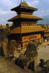 indigenous lifestyle. For its majestic monuments, colorful festivals and the native Newars best known for their long history of craftsmanship, the ancient city is also variously known as the "City of Culture", the "Living Heritage" and "Nepal’s Cultural Gem". Given such unequaled opulence in ancient art and culture, Bhaktapur is more like an open museum, and the ambiance here is such that it instantly transports visitors back by centuries the moment they step into its territory.
Bhaktapur has its gem in the Durbar Square—a World Heritage site listed by the UNESCO. Strewn with unique palaces, temples and monasteries best admired for their exquisite artworks in wood, metal and stone, the palatial enclave has bewitched pilgrims and travelers for centuries. Yet, they are not all though. Adding to the mesmerizing environs is the holy Himalaya that makes the backdrop of the city. Stretching all along the township, the panoramic Himalaya levitates in the skyline as if to keep vigilance on the city’s enviable beauty and splendor.
Bhaktapur, at 1,401 meters above sea level, spreads over an area of 6.88 square kilometers. It grows from a collection of villages strung along the old trade route between India and Tibet. The capital city of the Greater Malla Kingdom till the 15th century AD, Bhaktapur was founded in the 12th century by King Ananda Malla, but it was only in the early 18th century that this city took its present shape. It was at that time that many of Bhaktapur’s greatest monuments were built by the then Malla rulers.
indigenous lifestyle. For its majestic monuments, colorful festivals and the native Newars best known for their long history of craftsmanship, the ancient city is also variously known as the "City of Culture", the "Living Heritage" and "Nepal’s Cultural Gem". Given such unequaled opulence in ancient art and culture, Bhaktapur is more like an open museum, and the ambiance here is such that it instantly transports visitors back by centuries the moment they step into its territory.Bhaktapur has its gem in the Durbar Square—a World Heritage site listed by the UNESCO. Strewn with unique palaces, temples and monasteries best admired for their exquisite artworks in wood, metal and stone, the palatial enclave has bewitched pilgrims and travelers for centuries. Yet, they are not all though. Adding to the mesmerizing environs is the holy Himalaya that makes the backdrop of the city. Stretching all along the township, the panoramic Himalaya levitates in the skyline as if to keep vigilance on the city’s enviable beauty and splendor.
Bhaktapur, at 1,401 meters above sea level, spreads over an area of 6.88 square kilometers. It grows from a collection of villages strung along the old trade route between India and Tibet. The capital city of the Greater Malla Kingdom till the 15th century AD, Bhaktapur was founded in the 12th century by King Ananda Malla, but it was only in the early 18th century that this city took its present shape. It was at that time that many of Bhaktapur’s greatest monuments were built by the then Malla rulers.
Lalitpur
Lalitpur sub-metropolitan city, popularly known as Patan is currently one of the most vibrant cities of the kingdom of Nepal. It is located in about 5 kilometers south-east of Kathmandu. With its urban history dating back to as far as 2300 years, LSMC is one of the three major cities located inside the Kathmandu valley, besides Kathmandu and Bhaktapur.
Rich historic past, centuries old living culture of the people, thriving city development are what this historic city today boasts of. Of the fifty-eight municipalities of Nepal, Lalitpur is the third largest city.
Lalitpur, since ancient times has been preserving its unique place and role in the geo-political and economic arena of the country. For many centuries, Lalitpur was a sovereign city-state. In 1768 AD, King Prithivi Narayan Shah assimilated it into the Kingdom of Nepal.
Lalitpur is extremely rich in its arts and architecture and boasts on the largest community of artisans, especially metal and wood workers. In fact, the literary meaning of Lalitpur means the city of fine arts. It nurtures a large number of sacred buildings, temples, pagodas, Stupas and Shikharas, monasteries, math and Chaitya.
The city is renowned the world over for its art and craftsmanship and has produced number of famous artists and master craftsmen, the most famous being Arniko, who spread the legacy of this city far and wide.
In other words, Lalitpur may be termed the artistic capital of the country. In recognition, UNESCO has enlisted the conglomerate of the buildings in Patan Durbar Square as a World Heritage Site, one of the seven Heritage sites in the Kathmandu valley.
Located adjacent to the capital city of Kathmandu, LSMC has today become an integral part of the valley capital region, called Greater Kathmandu, consisting of two major cities Kathmandu, and Lalitpur.
According to tradition, Patan is the oldest city in the Kathmandu Valley. This claim has not been verified but the association of the four main Stupas with Ashok seems plausible. In fact, it seems not unlikely that having had Stupas built in widely separate places in India, and certainly having visited the birthplace of Buddha in Lumbini, legend has it that Ashok could also have erected these. The simple form of the mounds is also consistent with an early date of origin, though it remains to be seen whether the present earth covering masks an earlier brick structure.
The history of the Valley, in a proper sense, begins only with the Lichhavi and the inscriptions of Manadeva in the 5th century. The palace of this ruler, the Managriha or House of Mana , referred to in the inscriptions , may, perhaps, be identified with the Mansiggal which was later used by the Malla kings and which may have given its name to the area now called Mangal Bazaar adjoining Darbar Square. Two other palaces mentioned in the inscriptions cannot be identified although the name of one –Kailasakuta-seems to indicate a building with a high tower, supporting the view that even at that early date there were timber structures in the peculiar Nepalese style.
In any case, Patan has from very early times been a principal town, if not the capital city. It was known as Lalita Patana-the beautiful Patan-or Lalitpur. Some idea of its antiquity and of the growth of its religious institutions can be gained from inscriptions. J.C Regmi lists more than a dozen from Buddhist Vaishnavaite, and Shaivaite foundations in Patan of the period 464 –783 A.D. and many more of the period 987-1475.
Apart from the Stupas, it is not easy to determine which one is the oldest structure. The inscriptions of some of them point back to the 14th century or earlier, but even when organizations are old, the buildings, which house them, may have been reconstructed. Certainly the great period dates from the time of the Mallas, particularly the 16th -18th centuries when almost all of the most celebrated palaces and temples in the city were erected as well as many of the older religious buildings reconstructed or refurbished.
Perhaps because of its Ashokans tradition, Patan has remained a great center of Newari Buddhism, as shown by the large number of surviving Bahals, and also for Buddhist arts and crafts. The Lichhavi rulers seem to have been followers of Vishnu or Shiva. Their attitude to Buddhism is not clear, but in Patan, it seems to have held a special place. Neither has it been clear what form the Vihars took in early times nor what relations they had with the monastic communities of early or Himalayan Buddhism. The old courtyard plans remain, even when contained in an urban setting (itself unusual in early Buddhism), but the Sangha which gave rise to the form has long since departed. The modern Bahal is simply a combination of shrine and family residence, the modern Sangha an association of priests and laity descended from and retaining an attachment to its ancestor.
Lalitpur is believed to have been founded in the 3rd century B.C. by the Kirat dynasty and later expanded during Lichhavis period. It possesses a history of further expansion by the Mallas during the medieval period.
There are many legends after its name. The most popular one is the legend of the God Rato Machhindranath, who was brought to the valley from Kamaru Kamachhya, located in Assam, India, by a team of three people representing three kingdoms of the valley. One of them is called Lalit, a farmer who carried God Rato Machhindranath to the valley all the way from Assam, India. The purpose of bringing the God Rato Machhindranath to the valley was to overcome the worst drought in the valley. There was strong belief that the God Rato Machhindranath would make rain in the valley. It was Lalit's effort that the God Rato Machhindranath was settled in Lalitpur. Many believe that the name of the town is kept after his name Lalit and Pur means township in Nepal.
Lalitpur is said to have been founded by King Veer Deva in 299 A. D. but, there is unanimity among scholars that Patan was a well established and developed town since ancient times. Several historical records including many other legends also indicate that Patan is the oldest of three main cities of Kathmandu Valley. According to a very old Kirat chronicle edited by a noted research scholar Daniel Right, Patan was founded by Kirat rulers long before the Lichhavi rulers came into the political scene in Kathmandu Valley. According to Mr. Subba the earliest known capital of Kirat rulers was Thankot. Kathmandu, the present capital was most possibly removed from Thankot to Patan after the Kirati King Yalamber came into power sometimes around second century A. D. It is interesting to note that one of the most used and typical Newar name of Patan is Yala. It is said that King Yalamber named this city after himself and ever since this ancient city was known as Yala.
Kathmandu
Kathmandu (Nepali: काठमांडौ, pronounced: Nepal Bhasa: येँ महानगरपालिका) is the capital and largest metropolitan city of Nepal. The city is the urban core of the Kathmandu Valley in the Himalayas, which also contains two sister cities namely Patan or Lalitpur, 5 kilometres (3.1 mi) to its southeast (an ancient city of fine arts and crafts) and Bhaktapur, 14 kilometres (8.7 mi) to its east (city of devotees). It is also acronymed as 'KTM' and named 'tri-city'. Kathmandu valley is only slightly smaller than Singapore in terms of area.
The city stands at an elevation of approximately 1,400 metres (4,600 ft) in the bowl-shaped valley in central Nepal surrounded by four major mountains, namely: Shivapuri, Phulchowki, Nagarjun and Chandragiri. It is inhabited by 671,846 (2001) people. The Kathmandu valley with its three districts including Kathmandu District accounts for a population density of only 97 per km2 whereas Kathmandu metropolitan city has a density of 13,225 per km2. It is by far the largest urban agglomerate in Nepal, accounting for 20% of the urban population in an area of 5,067 hectares (12,520 acres) (50.67 square kilometres (19.56 sq mi
Kathmandu is not only the capital of the Federal Democratic Republic of Nepal but also the headquarters of the Central Region (Madhyamanchal) among the five development regions constituted by the 14 administrative zones of Nepal located at the central part of the country. The Central region has three zones namely, Bagmati, Narayani and Janakpur. Kathmandu is located in the Bagmati Zone.
Kathmandu, as the gateway to Nepal Tourism, is the nerve centre of the country’s economy. With the most advanced infrastructure among urban areas in Nepal, Kathmandu's economy is tourism centric accounting for 3.8% of the GDP in 1995–96 (had declined since then due to political unrest but has picked up again).
The city’s rich history is nearly 2000 years old, as inferred from an inscription in the valley. Its religious affiliations are dominantly Hindu followed by Buddhism. People of other religious beliefs also live in Kathmandu giving it a cosmopolitan culture. Nepali is the common language of the city, though many speak the Nepal Bhasa Newari as it is the center of the Newar (meaning: citizens of Nepal) people and culture. English and Hindi are understood by all of the educated population of the city. Besides a significant number of the population speaks any of the foreign languages like : French, German, Chinese, Hebrew, Korean etc. The literacy rate is 98% in the city.
Kathmandu is now the premier cultural and economic hub of Nepal and is considered to have the most advanced infrastructure among urban areas in Nepal. From the point of view of tourism, economy and cultural heritage, the sister cities of Patan(lalitpur) and Bhaktapur are integral to Kathmandu. Even the cultural heritage recognition under the World Heritage list of the UNESCO has recognized all the monuments in the three urban agglomerates as one unit under the title “Kathmandu Valley-UNESCO World Heritage Site.
Lumbini
Lumbinī (Sanskrit: लुम्बिनी, "the lovely") is a Buddhist pilgrimage site in the Rupandehi district of Nepal, near the Indian border. It is the place where Queen Mayadevi is said to have given birth to Siddhartha Gautama, who as the Buddha Gautama founded the Buddhist tradition. The Buddha lived between roughly 563 and 483 BCE. Lumbini is one of four magnets for pilgrimage that sprang up in places pivotal to the life of the Buddha, the others being at Kushinagar, Bodh Gaya, and Sarnath.
Lumbini is in the foothills of the Himalaya, 25 km east of the municipality of Kapilavastu, where the Buddha is said to have lived till the age of 29. Kapilvastu is the name of the place in question as well as of the neighbouring district. Lumbini has a number of temples, including the Mayadevi temple, and others under construction. Also here is the Puskarini or Holy Pond - where the Buddha's mother took the ritual dip prior to his birth and where he, too, had his first bath - as well as the remains of Kapilvastu palace. At other sites near Lumbini, earlier Buddhas were, according to tradition, born, achieved ultimate awakening and finally relinquished earthly form.
Lumbini is in the foothills of the Himalaya, 25 km east of the municipality of Kapilavastu, where the Buddha is said to have lived till the age of 29. Kapilvastu is the name of the place in question as well as of the neighbouring district. Lumbini has a number of temples, including the Mayadevi temple, and others under construction. Also here is the Puskarini or Holy Pond - where the Buddha's mother took the ritual dip prior to his birth and where he, too, had his first bath - as well as the remains of Kapilvastu palace. At other sites near Lumbini, earlier Buddhas were, according to tradition, born, achieved ultimate awakening and finally relinquished earthly form.
mount Everest
Mount Everest , is the world's highest mountain above sea level at 8,848 metres (29,029 ft). It is located in the Himalayas on the Nepal (Sagarmatha Zone)-China (Tibet) border.
In 1856, the Great Trigonometric Survey of British India established the first published height of Everest, then known as Peak XV, at 29,002 ft (8,840 m). In 1865, Everest was given its official English name by the Royal Geographical Society upon recommendation of Andrew Waugh, the British Surveyor General of India at the time, who named it after his predecessor in the post, and former chief, Sir George EverestChomolungma had been in common use by Tibetans for centuries, but Waugh was unable to propose an established local name because Nepal and Tibet were closed to foreigners.
The highest mountain in the world attracts many well-experienced mountaineers as well as novice climbers who are willing to pay substantial sums to professional mountain guides to complete a successful climb. The mountain, while not posing substantial technical climbing difficulty on the standard route (other eight-thousanders such as K2 or Nanga Parbat are much more difficult), still has many inherent dangers such as altitude sickness, weather and wind. By the end of the 2008 climbing season, there had been 4,102 ascents to the summit by about 2,700 individuals.[Climbers are a significant source of tourist revenue for Nepal, whose government also requires all prospective climbers to obtain an expensive permit, costing up to US $ 25,000 per person. By the end of 2009 Everest had claimed 216 lives,] including eight who perished during a 1996 storm high on the mountain. Conditions are so difficult in the death zone (altitudes higher than 8,000 m/26,246 ft) that most corpses have been left
Subscribe to:
Posts (Atom)